
Discovery in modern times
St Huberts Island can lay claim to being one of the first, if not the very first, location visited by First Fleeters after the settlement was established at Sydney Cove. This came about as a result of Captain Arthur Phillip's early recognition of the need to find more arable land and water for farming purposes; provision of sustenance for the new colony's settlers being of vital concern to him. He recognised that the area surrounding Sydney Cove would not provide him with the necessary resources and decided to explore the coast north of Sydney Heads in the hope that the "Broken Bay' referred to in Captain Cook's log book would be an entrance to a large river.
Accordingly, he and Lieutenant Bradley set out from Sydney Cove on the 2nd March 1788 (a Sunday) with an exploration party consisting of two long boats and crew, to explore the coast north of Sydney Heads. As evening closed they rowed with difficulty against the ebb tide and entered Broken Bay.
They anchored the boats about 9pm in a cove "... on the north-west side of the bay ..." and passed the night on the boats. This was probably due to their having seen signs of mias-mias (black camps) on the nearby beach - now known as Pearl Beach. All in all, the day and following night must have been exceedingly uncomfortable for the party!
On the following morning they set off in a northerly direction, but encountered a very strong current which forced them to lay up in a cove (almost certainly Booker Bay) until the tide turned and they could proceed.
They then "... went with the tide through a narrow opening between two necks of land (the Rip) which sloped on the left from a isolated wooden mountain (Blackwall) and on the right from a densely timbered hillside (Daleys Point) ...".
The two boats veered to the right and followed the contours of a creek (which would be Cockle Creek). A decision was made to land on a bank on the left hand side, where they set up their camp and obtained some respite from the heavy rain which fell during the morning. By afternoon the rain had eased, so the party was able to dry off their clothes before settling for the night.
Their rations were supplemented by crab which they caught and which, according to Bradley, "... proved very good ...". This overnight stay was on the eastern side of what is now known as St Huberts Island.
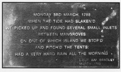
An obelisk with a plaque was erected and unveiled on Thursday 3rd March 1988 at 6pm in the reserve in Long Arm Parade, at the end of Barracouta Avenue, close to where the landing must have been made. The ceremony was part of the Bicentenary celebrations.
At daybreak on the following morning (4th March 1799), Phillip, Bradley and their group of mariners and sailors, set out to explore further. Again the tide prevented them from completing their survey, as they believed it would be unwise to row through shoal water where they could be stranded by the ebb tide. Undoubtedly they were concerned that they might be vulnerable to attack by aborigines, about whom they knew nothing.
What he saw obviously did not inspire Captain Phillip to explore further. There did not seem to be any land visible from the water which would support farming activities. As Governor of the new Colony, and being responsible for its survival, he knew it was important to find fertile river flats and to begin producing food quickly. Having set out with provisions for only seven days, he decided to turn back.
A dispirited party returned to Sydney Cove.